


FSX > Terrain Mesh > Page 1
9.63Mb (219 downloads)
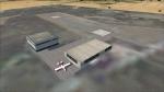
Xewkija Heliport is a small heliport / airfield on the Island of Gozo, a few miles out from Malta. It has two helipads which are connected by a 174 metre long strip of asphalt, which is occasionally used as a runway for light aircraft. It also has one parking spot, in case you're brave enough to fly a Twin Otter or BN2 Islander there. The helipads used to be used by Malta Air charter, but there are currently no scheduled commercial services from Xewkija. They are possible however, especially with the heliport having its own bus stop. This scenery was originally made for P3D by Dsimmer. Converted and modified for FSX by dbob .
Posted Oct 12, 2023 12:38 by dbob
68.46Mb (213 downloads)
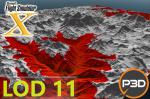
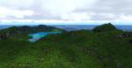
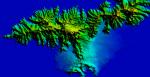
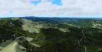
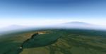
High quality lod11 terrain mesh for FSX and P3D. This mesh only covers the mountains around Mount Everest. I added screenshots of the map showing the area covered by the mesh.
Posted Oct 4, 2023 01:13 by juan30005
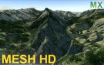
87.03Mb (338 downloads)
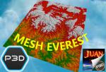
Mesh Mountains of Monterrey México for: Prepar3D and Flight Simulator X. High quality terrain mesh for FSX and P3D. This mesh only covers the Mountains of the north and south of Monterrey México. I added map snapshots showing the area covered by the mesh and other default terrain images and the ones I created. -install on P3D: copy "Mesh_Mountains_north_and_south_of_Monterrey.bgl" -> Prepar3D vX\Addon Scenery\scenery. (FSX style if you don't have these folders you can create them so adding scenarios is easier. using the "SceneryConfigEditor" program you add it to the prepar3d library) look the images p3d-add 1 and p3d-add 2 more info install scenery p3d: https://www.prepar3d.com/SDKv4/prepar3d/world/scenery_library/scenery_library_overview.html -install on FSX: copy "Mesh_Mountains_north_and_south_of_Monterrey.bgl" -> Microsoft Flight Simulator X\Addon Scenery\scenery
Posted Apr 26, 2021 02:48 by juan30005
0.68Mb (371 downloads)
This freeware addon upgrades the default terrain mesh of the American Samoa Islands to a stunning 10 meters in resolution. All Mesh has been derived from 1/3 arc-second USGS elevation data. Compatible with FSX, P3Dv2, P3Dv3, P3Dv4, & P3Dv5. Scenery created by Chris Britton (Rotornut44) of Emerald Scenery Design.
Posted Nov 8, 2020 16:11 by Emerald Scenery Design
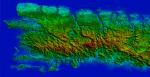
16.75Mb (574 downloads)
This freeware addon upgrades the default terrain mesh of Puerto Rico and the US Virgin Islands to a stunning 10 meters in resolution. Now, completely reworked from the ground up with the latest 2020 elevation data! All Mesh has been derived from 1/3 arc-second USGS elevation data. Compatible with FSX, P3Dv2, P3Dv3, P3Dv4, & P3Dv5. Scenery created by Chris Britton (Rotornut44) of Emerald Scenery Design.
Posted Nov 8, 2020 16:01 by Emerald Scenery Design
17.45Mb (826 downloads)
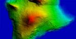
This freeware addon upgrades the default terrain mesh of the Hawaiian Islands to a stunning 10 meters in resolution. All Mesh has been derived from 1/3 arc-second USGS elevation data. Compatible with FSX, P3Dv2, P3Dv3, P3Dv4, & P3Dv5. Scenery created by Chris Britton (Rotornut44) of Emerald Scenery Design.
Posted Nov 8, 2020 15:47 by Emerald Scenery Design
13.93Mb (689 downloads)
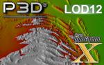
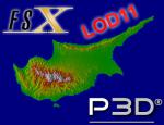
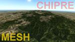
Cyprus Mesh (Chipre) LOD11 for Prepar3D and Flight Simulator X all version Free use high quality mesh.
included installation instructions for fsx and p3d
Posted Aug 2, 2020 17:40 by juan30005
22.43Mb (858 downloads)
P3D/FSX Italy ETM20m - Enhanced Terrain Mesh vol. 08The DTM (Digital Terrain Model), with national coverage, derives from the interpolation of the orographic data coming from the maps of the Italian Military Geographic Institute IGM (https://www.igmi.org/?set_language=it). The resulting product is a matrix with a regular pitch of 20 m, whose elements (pixels) show the values of the dimensions.
Posted Dec 20, 2018 01:55 by Giovanni Miduri
40.62Mb (809 downloads)
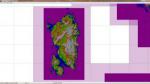
Italy - ETM Enhanced Terrain Mesh 0.73 arc sec (20 meters). This Terrain Mesh is fully compatible with FSX/P3D (all versions). This is a work in progress. Volume 07 - Sardegna.
Posted Dec 18, 2018 11:16 by Giovanni Miduri
47.84Mb (662 downloads)
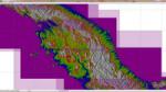
Italy - ETM Enhanced Terrain Mesh 0.73 arc sec (20 meters). This Terrain Mesh is fully compatible with FSX/P3D (all versions). This is a work in progress. Volume 06 - Liguria and Emilia Romagna
Posted Dec 18, 2018 09:54 by Giovanni Miduri