 |
Europe
FSX
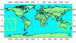
FSX World Wide SRTM 38M Mesh Europe Part 1. Includes the
complete set of SRTM 3, version 2, 75M mesh files for Europe.
This package is part of the freeware worldwide SRTM 3 v2 coverage
project. In 2 Parts. By Raimondo Taburet and J. De Ferranti.
155MB
Part
2 186MB |
|
 |
|
 |
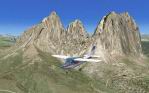
| FSX
Alps 38m Terrain Mesh. Terrain
mesh covering the alps - at 38 m resolution. Designed with the
FS X Sdk - including multilod and it is frames rates friendly.by
Raimondo Taburet. 38MB |
|
 |
| FSX
France 38 m Terrain Mesh Version 3.
Terrain mesh covering France - at 38 m resolution. Designed
with the FS X Sdk - This version replace previous released version
1 2 and fix -By Raimondo Taburet working with Emile De Mesmaeker.
51MB |
|
 |
| FSX
Hawaii 10m Terrain Mesh -
covering the islands of Hawaii - at 10 m resolution. Designed
with the FS X Sdk - including multilod and it is frames rates
friendly.by Raimondo Taburet. 63MB |
|
 |
| FSX
Scenery--World Wide Coverage SRTM 3, version 2, mesh of Africa.
Includes the complete set of SRTM 3, version 2, mesh files
for Africa. This package is part of the freeware worldwide
SRTM 3 v2 coverage project. Africa requires three files: By
Raimondo Taburet.
srt2afr.zip
180MB
srt2afr2.zip
155MB
srt2afr3.zip
172MB
|
|
 |
FSX
Inegi Mexico 38 M Terrain Mesh. Includes a complete coverage
FS X Terrain Mesh 38 M - for the whole of Mexico. Designed
using the Inegi Elevation Model - The scenery is split into
2 files.
ine38x.zip
138MB
ine382.zip
104MB |
|
 |
|
 |
| FS
X Australia and Pacific Ilands 76M Terrain Mesh.
Include the complete set of srtm 3 version 2 mesh files for
Australia and Pacific Islands - This package is part of the
freeware world wide srtm 3 v 2 mesh coverage project - Australia
and Pacific include 1 file: srt2aust.zip.by Raimondo Taburet.
106MB |
|
 |
|
|
| FSX
USA 10 M Terrains Project (Revised) - West
Coast Version 1.1. FSX USA 10 M Terrains Project is a freeware
mesh terrain add-on for FSX. It is designed to replace elevations
all over the United States, enhancing terrain from 38 m to
10 m, providing you a far more detailed terrain to fly over.
It is designed using the latest Ned 10 m elevation models
and compiled using multilod and a slight compression to keep
files to a reasonable size. This first release provides you
complete coverage for the west coast, split into six zip files.
By Raimondo Taburet. Public Domain.
File
1of 6 288MB
File2
of 6 427MB
File3
of 6 345MB
File4
of 6 385MB
File5
of 6 329MB
File6
of 6 309MB (fixed)
Patch
- Fixed spike 66.5MB
By Raimondo
Taburet. |
|
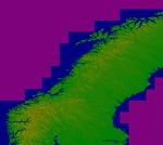 |
| FSX
Scandinavia 76 Version 2.
New coverage version 2 for the Freeware Scandinavia terrain
mesh - This file replace version 1 of such scenery - by Raimondo
Taburet - J. De Ferranti. 36MB |
|
 |
|
|
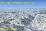
| FSX
38m (Lod10) Terrain Mesh files of the province of Quebec
(N45°-N52°, W56°-W80°). The 23 m (or 76m)
Canadian Digital Elevation Data for Quebec. http://www.geobase.ca
The 90-m digital elevation model (Shuttle Radar Topography
Mission - SRTM-3) ftp://edcsgs9.cr.usgs.gov/
pub/data/srtm/North_America/3arcsec/.
By Gilles Gauthier. Part 1 46MB
Part
2 45MB
Part
3 40MB
Part
4 44MB
Part
5 40MB
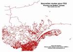
FSX
Quebec Roads. Addition of Roads for the province of Quebec,
Canada. For best scenery, use with lakes, shorelines and rivers
of the province of Quebec, Canada. Gilles Gauthier. 7.8MB |
|
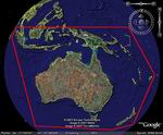 |
| FSX-STRM
Mesh for Australia, New Zealand and PNG (Papua New Guinea)
This STRM mesh will update your FSX default Mesh giving you
a much better resolution than the default mesh that comes
with default FSX. We have used the latest Data available fixing
all voids where possible. Thomas Trewin.
Part
1 95MB
Part
2 106MB
Part
3 51MB
Part
4 38MB |
|
 |
| FSX
19 M Balearic Terrain Mesh
Specifically designed for FSX this is a highly detailed mesh
at 19M resolution for the Balearic Islands - it offers a far
higher levels of details than srtm terrains mesh. by: Raimondo
Taburet. 1.5MB |
|
 |
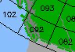
FS
X - Canada 19 M - Terrain Mesh - Part 1 The
canada 19 m terrain mesh fsx is designed using the cded elevation
models data - geobase.ca - It offers an improved terrain mesh
for the whole of Canada - This is File 1 - of Canada 19 m
freeware project. It is good - fun to fly over and Free !
All FSX mesh files compiled by myself are all designed to
work along each other - to provide the ultimate Freeware Mesh
Worldwide Coverage for the all continents. Designed by: Raimondo
Taburet. 263MB
FSX
Canada 19 M Terrain Mesh - Part 2
. 170MB |
|
 |
| FSX
ItalVFR - Trentino Alto Adige 2M Photorealistic Scenery &
Mesh Package. This scenery cover the whole of the Trentino
Alto Adige (Italy/Switzerland/French Alps) ) with photorealistic
scenery 2 m resolution - Summer only - part of the ItalVFR
photorealistic scenery of Italy.by: Raimondo Taburet.
Part
1: 300MB
Part
2: 229MB
Part
3: 389MB
Part
4: 387MB
Part
5: 263MB
Part
6: 260MB
Part
7: 373MB
|
|
 |
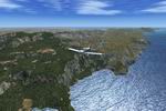
| FSX
New Zealand Terrain Mesh.
These files have had extensive work done on them to remove all
voids giving you the user much better STRM Terrain Mesh for
both the North and South Island of New Zealand. J.Harris. 32.4MB |
|
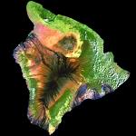 |
| FSX
10 meter Mesh for Hawaii. The
zip file contains mesh terrain files for the eight principal
islands of Hawai'i. The data supplied by the USGS Seamless server
was corrected to the necessary datum in use by FSX and any gaps
interpolated using Global Mapper. The files were then resampled
by the FSX SDKs. A FractionalBits setting of three was used,
except for the island of Hawai'i where the elevations of Mauna
Loa and Mauna Kea were beyond a FB=3 setting parameter. So the
island of Hawai'i was resampled with a FractionalBits setting
of two. In common speak, the FractionalBits settings allows
for a higher degree of processing between the data points, which
helps to eliminate any "stair-stepping" effect. Lance
Tucker. 34.8MB |
|
|
|